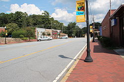
Union City, Georgia
Union City, Georgia | |
|---|---|
 Downtown Union City | |
| Nickname: The Progressive City | |
| Coordinates: 33°36′18″N 84°29′37″W / 33.60500°N 84.49361°W[1] | |
| Country | United States |
| State | Georgia |
| County | Fulton |
| Government | |
| • Mayor | Vince Williams |
| Area | |
• Total | 19.83 sq mi (51.37 km2) |
| • Land | 19.68 sq mi (50.96 km2) |
| • Water | 0.16 sq mi (0.41 km2) |
| Elevation | 971 ft (296 m) |
| Population (2020) | |
• Total | 26,830 |
| • Density | 1,363.66/sq mi (526.51/km2) |
| Time zone | UTC-5 (Eastern (EST)) |
| • Summer (DST) | UTC-4 (EDT) |
| ZIP code | 30291 |
| Area code | 770 |
| FIPS code | 13-78324[3] |
| GNIS feature ID | 2405627[1] |
| Website | unioncityga.org |

Union City is a city in Fulton County, Georgia, United States. The population was 26,830 at the 2020 census.[4]
History
[edit]
The Georgia General Assembly incorporated Union City in 1908.[5] One source claims that the town was named for the union of rails at a railroad junction,[6] while another version states the name commemorates a "Farmer's Union" which once was headquartered here.[5]
Geography
[edit]According to the United States Census Bureau, the city has a total area of 19.3 square miles (50.0 km2), of which 19.1 square miles (49.5 km2) is land and 0.2 square miles (0.5 km2), or 0.83%, is water.
Demographics
[edit]| Census | Pop. | Note | %± |
|---|---|---|---|
| 1910 | 534 | — | |
| 1920 | 620 | 16.1% | |
| 1930 | 776 | 25.2% | |
| 1940 | 884 | 13.9% | |
| 1950 | 1,490 | 68.6% | |
| 1960 | 2,118 | 42.1% | |
| 1970 | 3,031 | 43.1% | |
| 1980 | 4,780 | 57.7% | |
| 1990 | 8,375 | 75.2% | |
| 2000 | 11,621 | 38.8% | |
| 2010 | 19,456 | 67.4% | |
| 2020 | 26,830 | 37.9% | |
| U.S. Decennial Census[7] 1850-1870[8] 1880[9] 1890-1910[10] 1920-1930[11] 1930-1940[12] 1940-1950[13] 1960-1980[14] 1980-2000[15] | |||
| Race | Num. | Perc. |
|---|---|---|
| White (non-Hispanic) | 1,220 | 4.55% |
| Black or African American (non-Hispanic) | 22,686 | 84.55% |
| Native American | 51 | 0.19% |
| Asian | 135 | 0.5% |
| Pacific Islander | 12 | 0.04% |
| Other/Mixed | 733 | 2.73% |
| Hispanic or Latino | 1,993 | 7.43% |
As of the 2020 United States census, there were 26,830 people, 8,088 households, and 4,681 families residing in the city.
In 2000, the median household income was $35,322 and the median family income was $39,697. Males had a median income of $30,421 versus $28,111 for females. The per capita income for the city was $17,208. About 9.9% of families and 12.1% of the population were below the poverty line, including 14.0% of those under age 18 and 14.3% of those age 65 or over.
Education
[edit]K-12 schools
[edit]Union City is in the Fulton County School District.[17]
- Elementary schools
- C.H. Gullatt Elementary
- Liberty Point Elementary
- Oakley Elementary School
- Middle schools
- Bear Creek Middle (serves students in Palmetto and Fairburn)
- Camp Creek Middle School
- High school
- Creekside High School (serves students in Palmetto and Fairburn)
- Langston Hughes High School
- Benjamin E. Banneker High School
- Charter schools
- Hapeville Charter Career Academy
Colleges and universities
[edit]- Georgia Military College
References
[edit]- ^ a b c U.S. Geological Survey Geographic Names Information System: Union City, Georgia
- ^ "2020 U.S. Gazetteer Files". United States Census Bureau. Retrieved December 18, 2021.
- ^ "U.S. Census website". United States Census Bureau. Retrieved January 31, 2008.
- ^ "Explore Census Data". data.census.gov. Retrieved November 16, 2023.
- ^ a b "Union City". GeorgiaGov. Retrieved June 24, 2019.
- ^ Krakow, Kenneth K. (1975). Georgia Place-Names: Their History and Origins (PDF). Macon, GA: Winship Press. p. 237. ISBN 0-915430-00-2.
- ^ "Decennial Census of Population and Housing by Decade". United States Census Bureau.
- ^ "1870 Census of Population - Georgia" (PDF). United States Census Bureau. 1870.
- ^ "1880 Census of Population - Georgia" (PDF). United States Census Bureau. 1880.
- ^ "1910 Census of Population - Georgia" (PDF). United States Census Bureau. 1930.
- ^ "1930 Census of Population - Georgia" (PDF). United States Census Bureau. 1930. p. 253.
- ^ "1940 Census of Population - Georgia" (PDF). United States Census Bureau. 1940.
- ^ "1950 Census of Population - Georgia" (PDF). United States Census Bureau. 1980.
- ^ "1980 Census of Population - Number of Inhabitants - Georgia" (PDF). United States Census Bureau. 1980.
- ^ "2000 Census of Population - General Population Characteristics - Georgia" (PDF). United States Census Bureau. 2000.
- ^ "Explore Census Data". data.census.gov. Retrieved December 13, 2021.
- ^ "2020 CENSUS - SCHOOL DISTRICT REFERENCE MAP: Fulton County, GA" (PDF). U.S. Census Bureau. Retrieved September 24, 2024.
External links
[edit]- Official website
- Shadnor Baptist Church historical marker


